
Does the real estate sector understate physical climate risk?
Investors need to carefully consider physical climate risk, as assessments of properties may understate climate risks. They need to ask are the current models they use for climate risk evaluation up to date? We might think we are fully aware of the physical risks, but are we? Niu Dongxiao, Postdoctoral Researcher at Maastricht University School of Business and Economics, digs into these questions.
The extended lifespan of properties make them extra vulnerable
The rate of sea level rise is accelerating globally, and the frequency of natural disasters has increased fast over the past decade. Hurricane Ian, which slammed into Florida in September 2022, has caused more than 140 deaths and thousands of homes destroyed, resulting in $100 billion in losses. Residential and commercial real estate typically has a 50 to 80-year lifespan and thus is vulnerable to the long-term effect of natural disasters. Physical risks are taking a toll on properties’ stakeholders in different ways. Quality information and physical risk assessment at location and property level are therefore crucial inputs for investors to conduct investment risk analysis to protect properties.
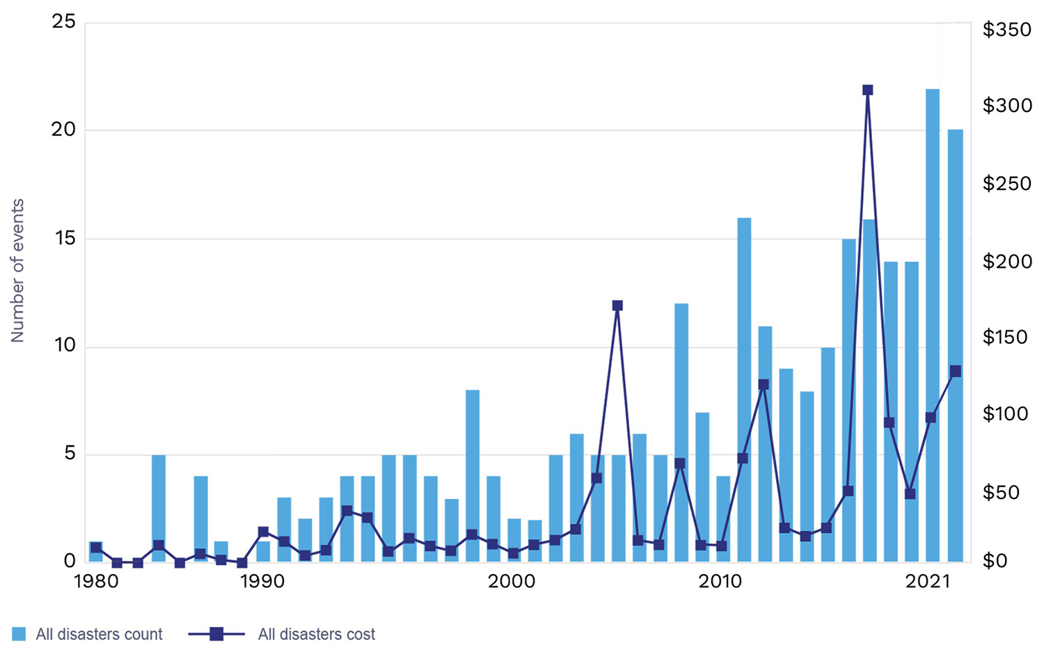
Figure 1. United States Billion Dollar Disasters by Year (Unadjusted)
Notes: Costs are in billions of dollars. Source: First Street Foundation
FEMA understates climate risks to properties
However, the flood maps of the Federal Emergency Management Agency (FEMA), which are often used to assess future flood risks, have proven to be out of date. According to a recent study by Holtermans, Niu, and Zheng (2022), it turns out that over 84% of the inundated properties in New York after Hurricane Sandy were located outside the flood zone designated by FEMA. The study shows that there is a substantial inconsistency between the predicted flood risks (from FEMA) and the realized damage caused by hurricanes. Obviously, with a large share of damaged buildings located outside the designated flood zones, the FEMA maps understate the climate risks to homes and businesses.
Four reasons why the FEMA maps are outdated
There are four reasons why FEMA maps are outdated:
- FEMA maps allocate a property to a hazard area (with a 1% risk of flood in the next 100 years) or non-hazard area. However, within the hazard area, there is no difference in the risk level between houses in different locations. This would lead to insufficient information on the variation of climate risks in a small area, such as a neighborhood or Census Block.
- FEMA maps do not account for sea level increases, river flooding, or heavy rainfall that could possibly lead to floods. After considering these factors, the number of properties facing flood risk in both coastal and inland areas significantly increases.
- FEMA maps are required to be updated and revised every five years, according to the National Flood Insurance Reform Act of 1994. However, there is still a large share of FEMA flood maps not updated in time, possibly due to budget constraints.
- Apart from flood risks, other types of climate risks such as wildfire and extreme temperature are not considered.
Diversity in models can result in conflicting climate risk data
With this, many private sector organizations such asFirst Street Foundation, and Four Twenty Seven have stepped in to try and plug the gap. They model flood risk factors on a property level from climatology, hydrology, recent climate events, and chronic climate change such as sea level rise. On the other hand, it is worth noting that no climate risk information is without faults. This is one of the reasons why many private data providers, using different models, come to conflicting results. The CFA Institute conducted a case study about APG’s approach to climate risk assessment, affirming that there is a large variation in results from different physical risk measuring methods, and no single model could account for all the risks.
Another general drawback from risk models of different providers is that they only capture ‘gross’ risks and often do not consider mitigation measures, either at county/municipality or at property level. For example, the Netherlands is below sea level, but the country has developed infrastructure to reduce flood risk. Also, private organizations are generally more expensive, and their data are not readily accessible to the public. This means that there are still several limitations for investors to consider when conducting physical risk assessment.
The good news is that, in the US context, FEMA is updating the National Flood Insurance Program’s (NFIP) risk rating methodology and implementing a new methodology called Risk Rating 2.0, which ensures that location specific risks are considered.
Reliable information provides insight and supports disclosure
Developing reliable and informative risk maps is a welcome development. It is also important to raise more awareness and push for more action from individuals, government bodies and other stakeholders in the industry. While climate scientists can help address the gap in access to information, it is important for investors to gain insight into property-level physical risks and mitigation measures to have a true understanding of underlying net investment risks.
GREEN asks real estate companies to give more insight into the extent of physical climate risk exposure, and asks them to disclose asset locations, together with an assessment of their exposure to asset-level physical risks and implemented adaptation/resilience measures.
About GREEN?
The network aims to ensure that the industry reaches the Paris goals on climate change. Through the power of coalition the institutional investors aim to steer real estate companies to improve their sustainability performance, and reduce their exposure to financial and non-financial climate risk. Currently the network targets listed and non-listed real estate companies. GREEN currently represents over EUR 2 trillion Assets under Management, representing asset managers as well as asset owners.
Check the members to see who is joining forces
Reference:
Holtermans, R., Niu, D., & Zheng, S. (2022). Quantifying the Impacts of Climate Shocks in Commercial Real Estate Market. Available at SSRN 4276452.